Why Understanding Permit Requirements is Essential
Understanding the importance of navigating the permit process may seem daunting, but it cannot be overstated. Permits ensure that your shed meets safety standards, adheres to zoning laws, and respects your community's guidelines. They are pivotal in avoiding legal issues, fines, and potential complications when selling your property.
Overview of Shed Installation in Canada
Canada's diverse geography and climate conditions mean that regulations may vary significantly from one municipality to another. Whether you're in the bustling streets of Toronto or the serene landscapes of the Yukon, the need for a permit hinges on several factors, including the shed's size, location, and purpose.
Navigating the Permit Process
Not all shed installations require a permit. Some small storage structures don't need a permit, but bigger sheds with electricity or plumbing probably do. Understanding the thresholds in your area is the first step toward compliance.
The best way to determine if you need a building permit application is to contact your local building department. They give detailed info for your project and location, so you know everything before moving forward.
Steps to Acquire a Shed Permit

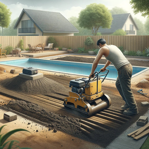
Acquiring a permit involves submitting detailed plans of your proposed structure, including its dimensions, materials, and location on your property. This section will prepare you for your application. It will also explain the review process and provide guidance on how to address any issues that may arise.
Factors Influencing Permit Requirements
The size of your shed often dictates whether you'll need a permit. Smaller sheds may fall under exemptions, but as size increases, so does the likelihood of needing official approval. Additionally, the structural complexity of your shed (e.g., adding electricity or plumbing) can impact permit requirements.
Your shed's location on your property can also influence permit needs. Proximity to property lines, environmental features, and community-specific zoning laws play a critical role in determining compliance.
Additional Requirements: Electricity and Plumbing
Integrating utilities into your shed adds another layer of complexity to permit applications. This section discusses the additional permits and inspections that these features may require.
The Consequences of Skipping the Permit Process
Not getting the right permits for your shed can result in big fines and changes or removal of the shed.
Unauthorized structures can impact your home insurance and resale value, making it difficult to sell your property in the future.

Preparing Your Application: What You Need to Know
When adding a shed to your yard in Canada, getting a permit is an important step that you must not forget. Preparing your application thoroughly is essential for a smooth review process. Here’s a breakdown of practical advice to guide you through this phase:
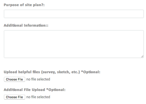
- Drafting Plans: Your application must include detailed plans of the proposed shed. These should cover the shed's dimensions, design, materials, and the exact location on your property. If possible, hire a professional to create these plans to ensure they meet local building codes and regulations. Ensure your plans include:
- Elevations: Show all sides of the shed.
- Floor Plan: Provide a bird’s eye view of the layout.
- Site Plan: Illustrate where the shed will sit in relation to property lines and other structures.
- Gathering Necessary Documentation: Along with your plans, you'll likely need to submit several other pieces of documentation, including:
- A property survey shows the boundaries of your property. It can also confirm that your shed will not exceed property lines or restrictions. This document is important for ensuring compliance with regulations and avoiding disputes with neighbors.
- Proof of Ownership: Typically, a deed or similar document proving you own the property.
- The description of work includes a detailed account of the shed's purpose and construction process.
Understanding Local Regulations: Before you start gathering your documents, make sure you understand the local regulations. This can include:
- Zoning Laws: Ensure your shed adheres to local zoning regulations, which can affect its size, location, and use.
- Building Codes: Your shed must comply with local building codes, which govern its construction standards.
- Get help from experts like contractors, architects, or government officials if you feel confused. They can make things clearer for you. They can offer insights into common pitfalls and advice on ensuring your application is complete.
- Some places may have additional requirements. This could include informing neighbors or assessing the surrounding environment. This is especially important if your property is near sensitive areas or has specific zoning regulations.
- Review and Revise: Before submitting your application, review all documents to ensure accuracy and completeness. Missing or inaccurate information can delay the review process.
- Submission: Check how your town wants applications. Some take them online, others need paper copies. Ensure you submit all parts of the application as instructed.
- After you apply, check your application status and respond promptly to any requests for more information or corrections. This proactive approach can help expedite the process.
To ensure your permit application for a shed in your yard is complete and follows the rules, follow these steps. This will help ensure that your application is ready for approval. The aim is to make the review process easy, so your property can be successfully added without any issues.
FAQ: Navigating Shed Installation and Permits
This section will answer the most common questions homeowners have about shed installation permits in Canada, providing clarity and confidence as you move forward with your project.
| FAQ | Answer |
|---|---|
| Can historical or cultural heritage designations affect my ability to install a shed in my yard in Canada? | Yes, historical or cultural heritage designations can affect your ability to install a shed. Properties located in designated heritage areas may face additional restrictions or require special approval to ensure that new structures, like sheds, do not detract from the historical or cultural significance of the area. |
| How do changes in municipal bylaws affect existing sheds that were installed without a permit? | Changes in municipal bylaws can retrospectively affect sheds installed without a permit. If a bylaw is updated to require permits for certain types of sheds, property owners may need to apply for a permit retroactively or modify the shed to comply with new regulations. In some cases, it might even be necessary to remove the shed. |
| Is there a difference in permit requirements for a shed that will be used as a home office versus one used solely for storage? | Yes, there can be a difference. Sheds intended for use as a home office might need to meet additional requirements related to electrical wiring, insulation, and accessibility. These requirements ensure the structure is safe and suitable for occupancy, which might not be as stringent for sheds used solely for storage. |
| What are the implications of installing a shed close to protected environmental features, such as wetlands or conservation areas? | Installing a shed close to protected environmental features may require additional permits or environmental assessments to ensure that the structure does not negatively impact the area. Restrictions may include limitations on the shed's size, location, and the materials used, to protect the natural habitat and biodiversity. |
| How can I appeal a decision if my permit application for installing a shed is denied? | If your permit application is denied, most municipalities offer an appeal process. This process typically involves submitting a written appeal to a review board or committee, which will reconsider your application. The appeal might require additional documentation or clarification on specific points of concern. |
| Are there any tax implications for adding a large shed to my property? | Adding a large shed to your property can potentially increase your property's assessed value, which in turn could affect your property taxes. The impact on taxes can vary depending on local assessment practices and the perceived value the shed adds to your property. |
| What specific considerations should be made for installing a shed in remote or rural areas of Canada? | In remote or rural areas, considerations might include access to the site, the impact of severe weather conditions, and the availability of services (such as electricity and plumbing) if needed. Additionally, local wildlife and environmental conservation laws may influence the permit process and design of the shed. |
Conclusion: Embracing the Permit Process for Your Shed Installation
Understanding and navigating the permit process for shed installation in Canada is crucial for a successful project. By following the guidelines outlined in this article, you can ensure your shed not only meets your needs but also complies with local regulations, safeguarding your investment and your peace of mind.
]]>


 To create the best cottage house site plan, you must consider many factors. Cottage houses are usually small, and they could be a primary residence or a cabin, vacation home, or beach house.


